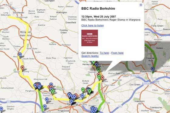
BBC Radio Berkshire came up with a novel solution after its website was inundated with hundreds of pictures and videos from the public after floods swept over its patch last week: broadcast journalist Oliver Williams created an interactive map using only the free Google Maps tool.
‘By the time we got to Sunday night, we just didn’t have a particularly good way of trying to display all the information we had received in one place that would make sense to people,’said Williams.
After a few hours of work on his laptop, Williams had created an interactive map plotting audio files of BBC Radio Berkshire reports – along with pictures and YouTube videos being sent in by the public – to the locations around the county that they referred to. Over the following days, BBC Berkshire journalists were able to add additional reports to the map as the story continued, including new flood warnings as they came in to the newsroom.
‘It’s quite difficult to decipher Environment Agency press releases and turn them into something that make sense, where you can see exactly where the river is in trouble. The maps seemed like the obvious answer,’he said.
Although the BBC journalists had full editorial control over which user contributions were added to the feature, the map was hosted outside the BBC web site on Google Maps.
‘I don’t know whether this is the BBC point of view, but personally I think that as a public service we should be less concerned about sticking our branding on everything and more concerned about ‘m more concerned about just making it work for people,’said Williams
Williams said the map has drawn attention well beyond Berkshire.
‘One woman wrote in from California saying that she used the map over and over again to see how the flood might be affecting her family in Pangbourne and people in New Zealand wrote in saying they were checking if Wallingford was flooded,’he said..
New tools have made it possible for those with only a small amount of technical expertise to create interactive maps that can link any type of online content and put stories in their geographic context.
‘It required a minimal amount of skill – I’m an online journalist, but I’m no computer programmer,’said Williams.
BBC Berkshire is planning to use a Google Map again for its coverage of Reading Festival at the end of the month.
Robin Hamman, a BBC senior broadcast journalist who has taught English Regions journalists to use social media tools, said Williams has been maintaining a personal blog for some years.
‘The fact that journalists feel like they can go out and experiment with these things and can do so quite openly has had some real benefits to the organisation itself,’said Hamman.
How We Built Britain is using Flickr to collect images from around the country, Newsnight has a Facebook group and PM presenter Eddie Mair has been using the text-message microblogging site Twitter. Reporter Ben Hammersley recently covered the Turkish elections while using Twitter and YouTube videos to provide behind-the-scenes look at his own reporting.
‘Once people are playing with these things in their personal lives, they often bring those skills and techniques they learn back into what they are doing at work, and that’s a key thing that’s happening right now,’Hamman said.
Rival Sky News has also started using Google Maps on its web site,, and recently used the tool in its coverage of the flooding in the north of England earlier in July.
Email pged@pressgazette.co.uk to point out mistakes, provide story tips or send in a letter for publication on our "Letters Page" blog
